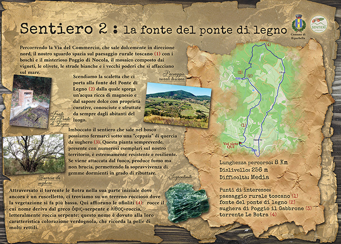
Sentieri di Riparbella n.2 "La fonte del ponte di legno"
Sentiero n. 2 la fonte del ponte di legno - Lunghezza: 8 Km. Dislivello 256 m. Difficoltà: media.
Iniziamo il percorso lasciando alla nostra sinistra il Camposanto di Riparbella e percorriamo per circa 2 kilometri la strada che sale dolcemente mantenendosi a mezza costa. Il nostro sguardo spazia sul caratteristico paesaggio rurale toscano (1) con il mare sullo sfondo. Attraversato un ponticello sul torrente Le Botra, scendiamo la scaletta per raggiungere la “fonte del ponte di legno”(2) da cui sgorga un’acqua dal sapore dolce e ricca di magnesio. Dopo pochi metri lasciamo la strada e svoltiamo a destra arrampicandoci sul sentiero di Poggio Il Gabbrone. Qui facciamo una breve deviazione per raggiungere una bella “ceppaia” di quercia da sughero(3). Ritornati sui nostri passi proseguiamo il tragitto sul sentiero che si inoltra nel bosco e, dopo aver incrociato alcuni viottoli, raggiungiamo il percorso n. 3 che seguiamo svoltando a destra. Dopo aver attraversato un suggestivo affioramento di “rocce verdi”(4), raggiungiamo lo spiazzo del “basto a rovescio” e da qui, seguendo la panoramica Via Chiannerina, scendiamo nuovamente al nostro punto di partenza.
Trail no. 2 the source of the wooden bridge - Length: 8 km. Difference in altitude: 256 m. Difficulty: medium.
We begin the route leaving the Riparbella cemetery on our left and follow the road that gently climbs for about 2 kilometers, keeping to the halfway point. Our gaze sweeps over the characteristic Tuscan rural landscape (1) with the sea in the background. After crossing a small bridge over the Le Botra stream, we go down the steps to reach the “source of the wooden bridge” (2) from which a sweet-tasting water rich in magnesium flows. After a few meters we leave the road and turn right, climbing up the path of Poggio Il Gabbrone. Here we make a short detour to reach a beautiful “stump” of cork oak (3). Having retraced our steps, we continue the journey on the path that goes into the woods and, after crossing some paths, we reach trail no. 3 which we follow, turning right. After crossing a suggestive outcrop of “green rocks” (4), we reach the “basto a rovescio” clearing and from here, following the panoramic Via Chiannerina, we descend again to our starting point.